The Earth Climate System and Climate Change: Meteorological Concepts
Slides from Alma Mater Studiorum Università Di Bologna about The Earth Climate System and Climate Change – Lecture 8. The Pdf explores fundamental meteorological concepts, meridional transport of water and energy in the atmosphere, and atmospheric circulation's impact on humidity and heat distribution. This University Science document details the various forms of energy involved in the climate system.
See more36 Pages


Unlock the full PDF for free
Sign up to get full access to the document and start transforming it with AI.
Preview
Useful Meteorological Concepts: Wind Nomenclature
ATER
STUD
M
ALMA
UNIVERSITA
DI BOLOGNA
DIORUM
A. D. 1088
ALMA MATER STUDIORUM
UNIVERSITÀ DI BOLOGNA
The Earth Climate System and
Climate Change - Lecture 8
Francesco Barbano
francesco.barbano3@unibo.itUseful Meteorological Concepts: wind nomenclature
U
> u
2
NORTH POLE (90° N. Latitude)
90
80
70
ASIA
NORTH AMERICA
90° MERIDIAN
Axis
of
60º
Earth
EUROPE
.30
NEW ORLEANS
(30° N. Latitude,
90° W. Longitude)
40°
30°
Center
of Earth
30° Latitude
20
AFRICA
Longitude
10°
100
90
80
70
60
50 40°
30
20
SOUTH
AMERICA
20
ATLANTIC
OCEAN
30°
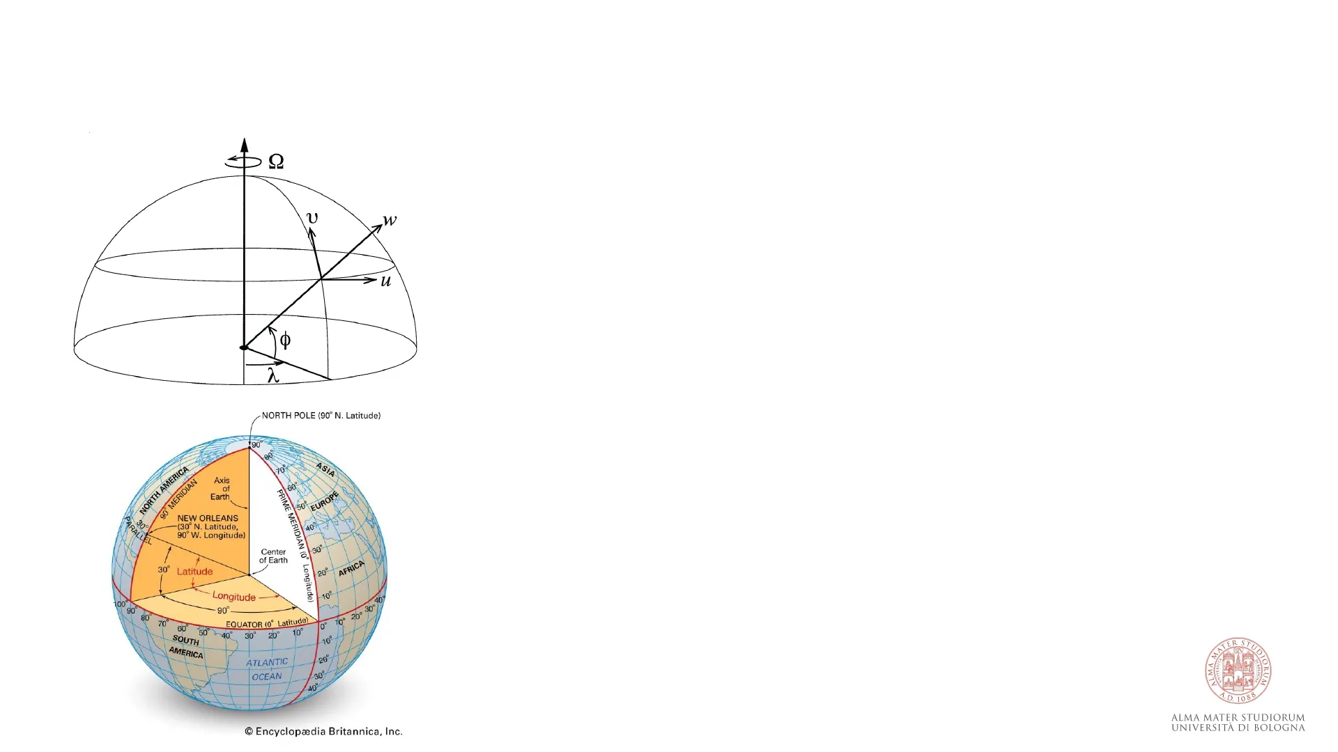
World meteorological weather system
The mean tropospheric circulation is the result of winds blowing
zonally, i.e., along parallels in the East-West direction (u),
meridionally, i.e., along meridians in the North-South direction (v) and
vertically, i.e., from the surface to the top of the atmosphere (w).
In the picture, latitude (o) and longitude (2) are expressed in terms of
the respective angles to the centre of the Earth and they represent the
angular distance from the equator and the prime meridian
(Greenwich), respectively. Q is the Earth velocity of rotation (constant).
TER ST
In meteorology, winds are called westerly when they flow from west to
east and easterly when they flow from east to west, following nautical
terminology
ALMA MA
UNIVERSIT
UDIORUM
DI BOLOGN
A. D. 1088
ALMA MATER STUDIORUM
UNIVERSITÀ DI BOLOGNA
2
@ Encyclopædia Britannica, Inc.
409
90°
. 30
EQUATOR (0° Latitude)
0° 10° 20°
10
PRIME MERIDIAN (0° Longitude)
PARALLE
Useful Meteorological Concepts: The Pressure Field
The pressure field is the map of pressure (spatial distribution of pressure) at a certain elevation in the
atmosphere. It is composed by isobars, aka lines at constant pressure.
Isobars are spread around the globe but they can in times or semi-permanently group in closed circles
defining high and low pressure conditions.
High and Low pressures are conditions
evaluated at the Earth's surface and certain
elevations into the troposphere according to
the weather pattern we want to study: The
most useful elevation where the pressure
field (distribution of high and low pressures)
is evaluated is 5-6 km (mid-troposphere).
In the mid/high-troposphere, the wind
follows the isobars!
1014
1005
800L
-1011-
-1017
999 Icelandic
-1002.
1008
-1020
1026
1011
Siberian
-1005.
-1014
jose High
H
-1017-2
-1020
1020
H
Azores H
`High 023-
30º
Pacific
High
1017
1014-
1011
1011
09 ITCZ
1014
ITCZ
1017
-1011
H
1014
1020
30°
1017
1014
1011
-1014
1011
-1008
★ 1011-X
1008
1005
1002
1005
999
-1002
60º
.996
999
(a) January
996
120°
1.60°
60°
120°
LAS 1008
1008
L
1020
H
1020
-1017
1008
_1011
1014
H
L LOW
1023
Aleutian)
L LOW
3
Useful Meteorological Concepts: High and Low Pressure Systems
Air in high pressure systems moves in a clockwise direction (in the northern hemisphere), while air in low-
pressure systems moves in an anticlockwise direction due to the rotation of the Earth. In the southern
hemisphere, the direction of the wind is the opposite.
The combination of surface pressure and upper-air pressure allow to determine how air moves in the
atmosphere both vertically (from the surface upwards in the troposphere) and horizontally (at the same
height).
Clouds from those it is raining
moist warm air rises
and cools down
dry and cold air
declines and
warms up
H
Low
pressure area
high
pressure area
ER STI
ALMA MAT
UNIVERSIT
UDIORUM
A. D. 1088
wind blow in the clockwise direction
from center.
ALMA MATER STUDIORUM
UNIVERSITÀ DI BOLOGNA
4
Useful Meteorological Concepts: High Pressure
A high pressure occurs at the surface where the air mass above the Earth is denser than in surrounding
areas, and therefore exerts a higher force or pressure.
Since it is denser than the surrounding, air subsides downwards and, at the same time, the air warms itself
up, so that no condensation and consequently no cloud formation can take place, which is why we
generally have fair weather (in mid-latitude regions) when we have high-pressure systems.
Because the surface air is being pushed down from the air above it spreads outwards as it cannot
penetrate the ground.
This high-pressure system is called an anticyclone.
In summer, anticyclones are associated with warm daytime temperatures in mid-
latitude regions. However, during winter high pressure systems over the centre of
Australia bring dry, cooler conditions.
high pressure
Diverging winds
High
5
Useful Meteorological Concepts: Low Pressure
A Low pressure develops at the surface if the density of the air near to the ground is decreasing while the
air is warming up. The warm air breaks away from the ground and rises up (thermic), what leads to a
pressure decrease at the ground level
In higher regions (on the vertical to the low pressure at the surface) the air pressure is rising because of the
inflowing warm air coming from the ground.
The decrease of the pressure near the ground leads to a spacious inflow of external air; we thus have wind
flowing horizontally towards the low pressure at the ground
This high-pressure system is called a cyclone.
By warming, the air can also absorb more water, potentially generating clouds of
fair weather (small cumulus like pouffes in the sky) or of bad weather (clouds that
can generate precipitation)
Low pressure v
Converging winds
Low
6
Useful Meteorological Concepts: Pressure and Rotation
Because of the insolation, the Earth's surface is warming up and acts like a heating to the surrounding air.
The air expands and lifts while heating and, because of the expansion, has a lower concentration than the
cold air, generating low pressure at the surface. As a consequense of this, the warm air rises up and warms
also the regions above.
At higher elevations, the warmer air starts to flow laterally over the adjoining cooler air packets. Because
of this, the air cools down further, getting heavier and finally sinking to the ground when it hits the less
cool regions. The region of the ground where the air becomes a high-pressure area.
Clouds from those it is raining
CH
dry and cold air
declines and
warms up
moist warm air rises
and cools down
H
Low
pressure area
high
pressure area
ER STI
ALMA MAT
UNIVERSIT
UDIORUM
A. D. 1088
wind blow in the clockwise direction
from center.
ALMA MATER STUDIORUM
UNIVERSITÀ DI BOLOGNA
7
Pressure and Rotation in Mid/High-Troposphere
In the mid/high-troposphere, the wind follows the isobars (see it on Windy)
· Horizontal pressure differences (high-to-low pressure) force the wind to flow from location at high to
those at low pressure.
· Pressure is quite constant along a parallel (east-west) while changes along meridians (north-south),
except in high- and low-pressure systems, isobars are parallel lines following latitude circles
· Pressure forces the wind to move from
high to low pressure, but Earth rotation
(Coriolis force) counteracts this pressure
force rotating the wind towards an east-
west direction
Pressure Gradient Force
5100
Path of air parcel
5160
30°
1014
1011
-1014
5220
1011
-1008
★ 1011-X
1008
1005
1002
1005
999
-1002
60º
.996
999
(a) January
120°
1.60°
60°
120°
1014
1005
1008
1011-
1017
999 Icelandic
1002-
_1008
H
L LOW
1023
Aleutian)
L LOW
-1005.
-1014
Siberian
Jose High
H
-1017-2
-1020
1020
H
Azores H
`High 023-
30°
Pacific
High
1017
1014-
1014
1011
1011
09 ITCZ
1014
ITCZ
1017
-1011
1020
L
H
1014
1020
-1017
1020
_1011
1008
LAS 1008
1008
H
1017
Coriolis force
5280
996
8
isoline of
constant height
-1020
1026
1011
Mean Tropospheric Circulation: Meridional Mean Circulation
Mean Tropospheric Circulation - The Meridional Mean Circulation
The meridional and vertical components of wind are much weaker than the zonal wind. Maximum mean
meridional winds are only about 1 m/s and mean vertical wind speeds are typically a hundred times
smaller than the mean meridional wind.
Vertical and meridional components of wind are typically studied together into what is known as the
meridional mean circulation, a cell-like system going horizontally from the equator to the poles (and
viceversa) and vertically from the surface to the tropopause (and viceversa)
Two cells are possible in the atmosphere:
- A thermally induced cell (or direct cell) where the air lifts
vertically above warm surfaces and after travelling
polewards it sinks on colder surfaces - An indirect cell where air lifts above cold surfaces and after
travelling towards the equator it sinks on warmer surfaces
(this is how energy and heat travels on average, not the
actual wind motion)
y>0
₡<0
W
C
W
C
Thermally induced cell
Indirect cell
A.D. 1088
ALMA MATER STUDIORUM
UNIVERSITÀ DI BOLOGNA
10
Mean Tropospheric Circulation: Non-rotational Water World
Mean Tropospheric Circulation - Non-rotational Water World
Cold
Convection cell
Surface flow
Convection cell
Hot
Surface flow
Cold
The different global insolation cause the air to warm
the most within the tropical region.
At the equator, air rises due to convection from the
surface towards the tropopause: this process reduces
the surface pressure and enhances that at the
tropopause.
At the surface, the air is horizontally pulled by the low
pressure (convergence) forcing a southward (in NH)
wind at the surface. At the tropopause, high pressure
pushes air towards the polar regions (divergence).
Air mass moving polewards decrease their
temperature and descends to the surface at the poles
inducing a high pressure and forcing surface winds
winds
ER
towards the equator
UNIVERSIT
ALMA
DIORUM
A.D. 1088
ALMA MATER STUDIORUM
UNIVERSITÀ DI BOLOGNA
12
Mean Tropospheric Circulation: Rotational Water World
Mean Tropospheric Circulation - Rotational Water World
Northern
hemisphere
Actual path
Path if
Earth did
not rotate
Rotation of Earth
Equator
Southern
hemisphere
The Coriolis effect is the result of the apparent force
named after Coriolis an atmospheric parcel feels when
moving on a rotating atmosphere (as a consequence of
Earth rotation).
The Coriolis effect causes moving air parcels to be
deflected to the right in the northern hemisphere and
to the left in the southern hemisphere (in the
opposite direction of the Earth rotation)
TER ST/
MA
ALMA
UNIVERSITA
DI BOLOGNA
M
A.D. 1088
ALMA MATER STUDIORUM
UNIVERSITÀ DI BOLOGNA
DIORUM
13
Rotational Water World: Coriolis Force and Circulation Cells
Mean Tropospheric Circulation - Rotational Water World
1
L
H
L
H
Introducing planet rotation means introducing the
Coriolis force to the equation.
As the air at the equator warms, ascend and move
polewards, Coriolis forces an eastward rotation of the
wind that breaks the meridional flow and induces air
sinking towards the ground in the subtropics (30°).
Once the air has descended back to the ground, it
returns to the equator and is deflected to the east
(trade winds).
Similar behaviours are observed at 60°, forming the
three-cell circulation we observe globally.
TER ST
ALMA MA
UNIVERSITA
DIORUM
DI BOLOGN
A. D. 1088
ALMA MATER STUDIORUM
UNIVERSITÀ DI BOLOGNA
14
Can’t find what you’re looking for?
Explore more topics in the Algor library or create your own materials with AI.