Geography of Greece and Italy for High School
Outlines from High School about Geography of Greece. The Summaries explore the physical characteristics of Greece and Italy, detailing mountains, seas, and islands for both regions. This material is suitable for high school students studying Geography.
See more8 Pages

Unlock the full PDF for free
Sign up to get full access to the document and start transforming it with AI.
Preview
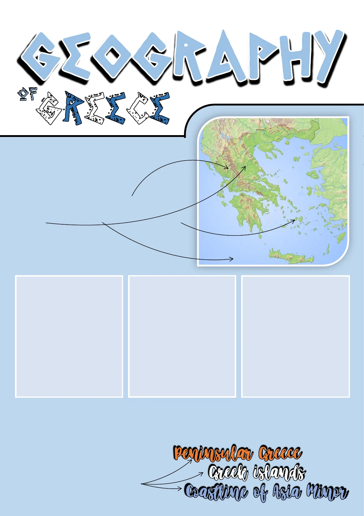
Greece's Strategic Location and Geography
ELEGRAPHY Greece is strategically situated between Europe and Asia, and this location had a great impact on its history. There are two basic elements to its geography: the mountains, which leave little room for cities to develop on the plains, and the sea, full of islands, which eventually became a ponto for the Greeks (that is, a bridge, a means of communication).
-
THERE ARE TWO SEAS SURROUNDING GREECE, THE IONIAN AND THE AEGEAN. SOME IMPORTANT MOUNTAIN RANGES RISE CLOSE TO THEM: THE OLYMPUS, THE CITHAERON, THE PARNASSUS, AND THE HELICON. ALL OF THEM WERE OF SPECIAL RELEVANCE IN GREEK MYTHOLOGY.
-
THE PLAIN, A PERFECT SPOT FOR THE DEVELOPMENT OF CITIES, LIES ON THE NARROW LAND STRIPS BETWEEN THE SEA AND THE MOUNTAINS. FIG TREES, OLIVE TREES AND WHEAT FIELDS SHAPE MOST OF THE GREEK LANDSCAPE, ESPECIALLY THE REGION OF ATTICA, IN WHICH ATHENS IS FOUND. THE GREEK RIVERS ARE SHORT AND HAVE AN INTERMITTENT COURSE. SOME OF THEM, WHOSE WATERS RUN WITH MYTHS AND LEGENDS, LIKE THE ACHERON AND THE PINEIOS, FLOW THROUGH FORESTED LAND AND CARRY MORE WATER.
This landscape, in which sea, valley and mountain coexist, favoured isolation and made communications on land difficult. As a consequence, the Greeks saw the sea as their best way of communication, which boosted the early foundation of colonies throughout the Mediterranean Sea.
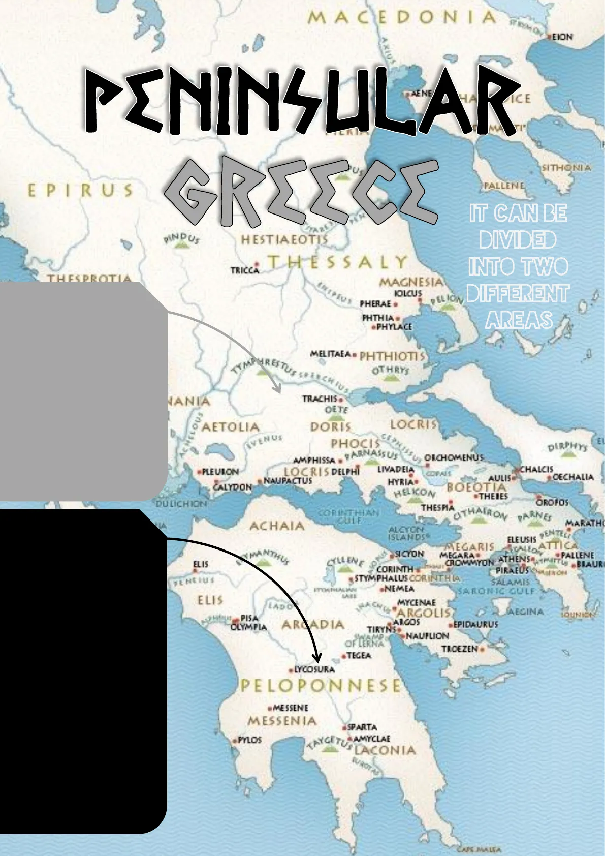
Divisions of Greek Geography
With all these things considered, the geography of Greece can be divided into three large areas: peninsular Greece Creele islands Coasttime of Asia MinorMACEDONIA EION Axios PENINSULAR GREEEL PALLENE EPIRUS PINDUS HESTIAEOTIS THESSALY INTO TWO MAGNESIA IOLCUS PEL ION PHERAE . DIFFERENT AREAS MELITAEA . PHTHIOTIS YMP RESTUS OTHRYS TRACHIS. JANIA OETE AETOLIA DORIS LOCRIS EL DIRPHYS PARNASSUS OKCHOMENUS LOCRIS DELPHI COPAIS CECHALIA NAUPACTUS HYRIA BOEOTIA HELICON THEIES THESPIA CORINTHIAN CULE OTH NES ACHAIA ALCYON ISLANDSS ELEUSIS SICYON MEGARA PALLENE BRAUR CORINTH STYMPHALUS CORINTH LA PIRAEUS VENCIUT SALAMIS .NEMEA SARONIC GULF ELIS LADO ARGOLIS LOUNION ARGOS OLYMPIA TIRYNS NAUPLION OF LERNA TACEZEN . .TEGEA .LYCOSURA PELOPONNESE ·MESSENE MESSENIA ISPARTA .PYLOS KAYGE AMYCLAE LACONIA CARE MALA
The Peloponnese Peninsula
The Peloponnese (or Peloponnesus). This peninsula is connected to the continent by the Isthmus of Corinth. One of its most important regions, especially during the Mycenaean Age, was Argolis, where the cities of Mycenae, Argos, Corinth and Epidaurus were found. Another relevant region was Laconia, best known for its capital, Sparta.
Mainland Greece Regions
SITHONIA IT CAN BE DIVIDED TRICCA THESPROTIA Mainland Greece. Some of its most important regions were Altica (with Athens as capital), Bocotia (capital in Thebes), and Macedonia in the north (with it) capital in Pella, where Alexander the Great was born).
Aegean and Ionian Islands
FROTINDY VENUS PHOCIS AMPHISSA -FLEURON LIVADEIA CHALCIS AULIS CALYDON DULICHION OROPOS MARATH TE MEGARIS A CA ELIS GYLLENE CROWMYON ATHENS ETTMATHALIAN LABI MYCENAE AEGINA PISA ARCADIA EPIDAURUS D PHTHIA .PHYLACEMETHYMNA THE LESVOS SCYROS EUBOEA DIRPHYS S CHALCIS CECHALIA AEGEA OROPOS RNES MARATHON PENTELI ELEUSIS TTICA ON ATHENS BRAURON PIRAEUS SALAMIS ONIC GULF AEGINA LOUNION CEA JRUS MYKONOS The Aegean Islands, in the Aegean Sea. They are constituted by several archipelagos:
-
NAXOS PAROS SERIPHOS ARE THE FOLLOWING CALLISTE (THERA) ANAPHE The lonian Islands, in the lonian Sea. Among them, Ithaca stands out as the home of Ulysses.
Notable Aegean Archipelagos
CRETAN SEA The Cyclades: Thira (now Santorini), Paros and Naxos are of note . CYDONIA CRETE CNOSSUS. MILETUS IDA LICTUS LYCASTUS DIKTE . CORTY'S PHAESTUS .RHYTIUM GREEK SAPYLUS AULIS TIA THEIES RIS . PALLENE IONIA ISLANDS 5 EPHE ICARIA THE MAIN DELOS DELOS (ORTYGIA") ISLANDS The Sporades: these islands are disseminated in the north of the Aegean and all along the coasts of Asia Minor. Lesbos, Chios, Samos and Rhodes are the most important ones. Crete, the biggest of all the Greek islands.THÀSOS SAMOTHRACE CYZICUS DOLIONIANS
Coastline of Asia Minor
COASTLINE SITHONIA MYRINA EF TENEDOS TANDER MYSIA THEIE .LYRNESSUS CHRYSE FEDASUS METHYMNA LESVOS LYDIA THE CHIOS DIRPHYS REGIONS CECHALIA EGEAN ROTOS SEA Es MARATHON ENTELE TTICA · PALLENE ATTL BIAURON ANDRO LANDER ICH SAMOS ICARIA MYKONOS MILETUS DELOS DELOS (ORTYGIA") NAXOS PAROS NĪSY ROS SYME RHODES TALYSUS CAMEIRUS CALLISTE (THERA) ANAPHE LINDUS CRETAN SEA CARPATHUS Its regions were Phrygia, Lydia, Lycia, Mysia and Caria. Several of the most important cities in Greek history flourished along the coasts of Asia Minor, such as Troy, Pergamum, Ephesus, Miletus and Halicarnassus. TROY TROAD LEMNOS ASIA MINOR EUBOEA SAPYLUS SARDIS TMOLUS ARE IONIA EPHESUS CARIAJEOGRAPHY 30 Wwwhoy Budapest Zürich n Theresiępet 16 rden venedig Busen von Genua Toulon Korsika M Strate Straße von Otranto Busen Turent e Iparische Inseln M 1 Palermo Lup Spartiverto sizilien Catania Syrakus - B 8st. Länder Greenwich, 10 1 Masstab 1:0.000000 "Allemeter
Geography of Rome
OF ROME Rome was at the heart of Lazio, Italy and the Mediterranean Sea. The city was born in the centre of the agricultural plain of the Lazio region (Lactium), on the banks of the river Tiber and beneath the slopes of the seven hills which surround the plain. Due to its location, equidistant from the north and south of Italy and in the middle of the Mediterranean, Rome received influence from the N four cardinal points.
Italian Mountains
MOUNTAINS As it has been said, the Italian Peninsula occupies the centre of the Mediterranean. It's shape is well- known: the famous tall boot. It is about 1000 km long from north to south, and its width is about 150 km at the central part. The Apennine Mountains rise along the whole peninsula and separate both coastlines. On the north, Italy remains separated from the continent by a huge obstacle: The Alps, which remained impenetrable for a long time. Once the Romans managed to go through them, the course of History changed forever.
The Alps and Apennines
The Alps The Apennines
Italian Seas and Islands
E S Messin n Esseg &SeubalSEE and ISLANDS Three seas bathe the shores of Italy: The Adriatic, to the east; the Tyrrhenian, to the west; and the lonian, to the south. There are also some islands; to the south, Sicily, one of the biggest in size; to the west, Corsica (today it belongs to France), Sardinia and the small islands of Elba and Capri.
Italian Regions Map
AUSTRIA SWITZERLAND HUNGARY SLOVENIA CROATIA FRANCE BOSNIA & HERZEGOVINA Ligurian Sea ITALY Corsica (FRANCE) Adriatic Sea Sardinia (ITALY) Tyrrhenian Sea Ionian Sea Sicily (ITALY) Mearranjar Sea TUNISIA ALGERIA 0 500 LIBYA Kilometres Trentino Alto Adige Bolzano >>>>>> REGIONS> Genova Liguna Veneto Venezia Firenze Toscana Emilia Romagna Perugia Umbria Marche Ancona Abruzzo L'Aquila Pescara Lazio Città del Vaticano Roma Molise Campobasso Napoli Campania Puglia Bari Sardegna Cagliari Sicilia Palermo Basilicata Potenza Calabria Catanzaro Reggio Calabria
Historical Italian Regions
IN THE NORTH, WE FIND THE CISALPINE GAUL; IN THE CENTRE, ETRURIA, UMBRIA, PICENUM AND THE LAZIO. SOUTH OF THE LAZIO WAS CAMPANIA, POSSIBLY THE MOST FERTILE REGION OF ALL ITALY. SAMNIUM WAS ON THE SOUTH-EASTERN TERRITORY. AT THE SOUTHERN END, THE PENINSULA WAS STRUCTURED IN THREE REGIONS: APULIA, LUCANIA AND BRUTTIUM. Lombardia Milano NORTH 125 250 Valle d'Aosta BolognaRIVERS 9 Piave Adda 4 Ticino 7 5 Oglio Po 2 Adige 1 10 Reno 6 8 Tanaro Arno 3 Tiber
Main Italian Rivers and Soil
THERE ARE THREE MAIN RIVERS IRRIGATING THE ITALIAN SOIL: THE PO, ON THE NORTH, WHICH FLOWS THROUGH THE CISALPINE GAUL DIVIDING IT INTO TWO PARTS; THE ARNO, WHICH IRRIGATES ETRURIA, AND THE TIBER, WHICH ACTED BOTH AS A NATURAL BORDERLINE AND AS A CONTACT POINT BETWEEN ETRURIA UMBRIA AND THE LAZIO. THE ITALIAN SOIL IS VARIED AND QUITE FERTILE, AND ITS SUBSOIL IS FAIRLY RICH WITH METALS: COPPER, LEAD, TIN AND ZINC ARE ABUNDANT.
Conclusion: Greeks vs. Romans
CONCLUSION As a conclusion. IT can be said That The Greeks were mostly sailors. Travellers and merchants. On The other hand, The Romans were mostly Farmers and had a sedentary nature, because Italy's soil and climate provided Them with everything They needed To survive. Besides, The Romans had a pragmatic spirit, which led Them To conquer The known world in classical antiquity.
Additional Resources
https://youtu.be/JOP.jQ22wKww (A Description of Ancient Greece. Sp. 1'59") https://youtu.be/NqDMPDGTqtQ (Geography of Greece. Sp. 3'13") https://youtu.be/73fy.jcl5dgM (Greek Geography. 6'59") https://youtu.be/8 _-- 150AdKY (We Travel around the Roman Empire. Sp. 9'12")
Homework and Investigation
HOMEWORK THINK, UNDERSTAND, INVESTIGATE
- WHICH CURRENT COUNTRY CORRESPONDS TO THE FORMER ASIA MINOR?
- WHAT ARE THE CAPITALS OF THE REGIONS OF ATTICA AND LACONIA RESPECTIVELY?
- ON A BLANK MAP, PAINT WITH DIFFERENT COLOURS THE THREE AREAS IN WHICH
WE HAVE DIVIDED THE GEOGRAPHY OF GREECE. THEN LOCATE IN EACH AREA THE
FOLLOWING REGIONS:
- ATTICA, BOEOTIA, PHRYGIA, MACEDONIA, THE PELOPONNESE AND THRACE.
- ON THE SAME MAP, LOCATE THE FOLLOWING CITIES:
- ARGOS, CORINTH, SPARTA, MILETUS, OLYMPIA, THESSALONICA AND TROY. WHICH OF THEM ARE SITUATED IN THE PELOPONNESIAN PENINSULA?
- INDICATE THE LOCATION OF THESE ISLANDS: CORFU, CRETE, ITHACA, LESBOS, RHODES, SALAMIS AND SAMOTHRACE. IN WHICH SEA IS EACH OF THEM?
- SOME OF THE NAMES OF CITIES, ISLANDS, ETC. THAT YOU HAVE STUDIED ARE LINKED TO GREEK MYTHS. GATHER INFORMATION ABOUT ITHACA, MOUNT OLYMPUS, MOUNT PARNASSUS AND TROY, AND DESCRIBE THE ROLE THEY PLAYED IN MYTHOLOGY.
- ARE THE TERRAINS OF GREEK, ITALY AND SPAIN ALIKE? LIST THE SIMILITUDES AND DIFFERENCES BETWEEN THEM.
- COMMENT THE THREE MAIN GEOGRAPHICAL FEATURES OF ITALY.
- WHY WAS ROME PARTICULARLY WELL SITUATED? (GEOGRAPHICALLY SPEAKING).
- CHOOSE THREE MODERN CAPITAL CITIES AND ANALYSE THEIR LOCATION. LIST ADVANTAGES AND DISADVANTAGES OF THEIR GEOGRAPHY.
- ON A BLANK MAP, WRITE AND PAINT THE FOLLOWING GEOGRAPHICAL ELEMENTS:
- SEAS: TYRRHENIAN AND ADRIATIC.
- RIVERS: PO AND TIBER.
- MOUNTAINS: THE ALPS AND THE APENNINES.
- ISLANDS: CORSICA, SICILY AND SARDINIA.
French Territory Question
" WHICH IS NOWADAYS PART OF THE FRENCH TERRITORY? O CITIES: ROME, NAPLES, FLORENCE AND POMPEII
Can’t find what you’re looking for?
Explore more topics in the Algor library or create your own materials with AI.
