Estratigrafia: conceptos basicos de litoestratigrafia y formaciones geologicas
Diapositivas de Universidad sobre Estratigrafía. El Pdf explora los conceptos fundamentales de la estratigrafía, con un enfoque en la litoestratigrafía, incluyendo la definición de formaciones geológicas, grupos y supergrupos, y los criterios para distinguir unidades estratigráficas en Ciencias.
Ver más58 páginas


Visualiza gratis el PDF completo
Regístrate para acceder al documento completo y transformarlo con la IA.
Vista previa
Estratigrafía: Conceptos Básicos
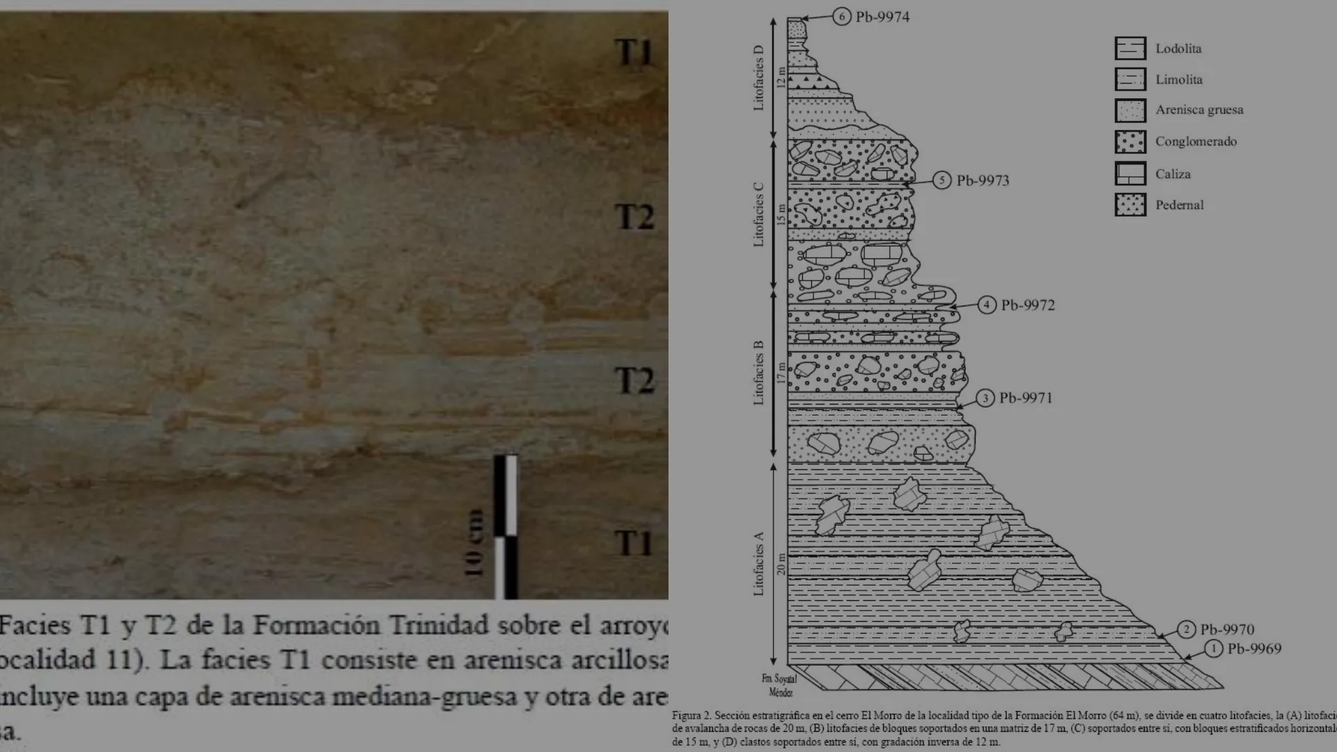
6 Pb-9974 TI T2 Estratigrafía T2 Conceptos básicos, foco a la Litoestratigrafía 10 cm TI Facies T1 y T2 de la Formación Trinidad sobre el arroy ocalidad 11). La facies T1 consiste en arenisca arcillosa ncluye una capa de arenisca mediana-gruesa y otra de are a. Lodolita Litofacies D Limolita 12 m Arenisca gruesa Conglomerado Caliza 5 Pb-9973 Litofacies C 15 m Pedernal 4 Pb-9972 17 m 3 Pb-9971 Litofacies A 20 m 2 Pb-9970 - Pb-9969 Fm. Soyatal Méndez
Figura 2. Sección estratigráfica en el cerro El Morro de la localidad tipo de la Formación El Morro (64 m), se divide en cuatro litofacies, la (A) litofaci de avalancha de rocas de 20 m, (B) litofacies de bloques soportados en una matriz de 17 m, (C) soportados entre si, con bloques estratificados horizontal de 15 m, y (D) clastos soportados entre si, con gradación inversa de 12 m.¿Qué es la estratigrafía?
- ¿ Ustedes cuando ven estratos en la carretera o en un viaje, estos tienen alguna referencia?
- La estratigrafía es un área de la geología que busca contextualizar los estratos
- objetivoEstratigrafía Stratum (latín) Graphia (griego) Descripción de todo cuerpo de roca formado en la corteza terrestre (estrato) y su organización en unidades distintivas, útiles y cartografiables basados en sus propiedades o atributos inherentes con el fin de establecer su: distribución, relación espacial, sucesión temporal e interpretación geológica. (Definición obtenida de la Comisión Internacional de Estratigrafia ICS)Estratigrafía
Propiedades Inherentes de la Estratigrafía
- Estas propiedades inherentes pueden ser estudiadas desde distintas aristas: o Litoestratigrafía O Bioestratigrafia o Magnetoestratigrafía o Quimioestratigrafía o Estratigrafía secuencial (o de secuencias)
Stratigraphic Categories Principal Stratigraphic Unit-terms Lithostratigraphic Group Formation Member Bed(s), Flow(s) Unconformity-bounded Synthem Biostratigraphic Biozones: Lineage zones Range zones Interval zones Assemblage zones Abundance zones Other kinds of biozones Magnetostratigraphic polarity Polarity zone Other (informal) stratigraphic categories (mineralogic, stable isotope, environmental, seismic, etc.) -zone (with appropriate prefix) Equivalent Geochronologic Units Chronostratigraphic Eonothem Erathem System Series Subseries Stage Substage Eon Era (Chronozone) (Chron) Period Epoch Subepoch Age Subage
Litoestratigrafía vs. Estratigrafía de Secuencias
- Una sucesión sedimentaria corresponde a un conjunto de estratos dispuestos cronológicamente (siguiendo el principio de superposición de Steno), a lo largo del tiempo geológico, bajo condiciones específicas. Uso "general".
- En cambio, una secuencia sedimentaria (o secuencia depositacional) corresponde a una sucesión relativamente concordante de estratos genéticamente relacionados, limitados en su superficie superior e inferior por discordancias y sus concordancias relativas (Vail et al., 1977). Su uso radica en la Estratigrafia secuencial.
Tiempo Geológico y Unidades
- El paso del tiempo desde la formación de la Tierra se puede dividir en unidades. o Ejemplo: Pérmico o periodo que va entre 251 M.a. y 299 M.a.
- Se utilizan abreviaturas para los años: o M.a. o K.a. o G.a.
Eon - Today Hadean 13% Phanerozoic 12% Phanerozoic -541 Ma Precambrian Proterozoic - -2.5 Ga Archean Archean 33% Proterozoic 42% - 4.0 Ga Hadean - 4.54 Ga
Geocronología y Cronoestratigrafía
Tiempo Geológico · Geocronología · Cronostratigrafía La Formación Río Damas (Chile central) es una sucesión volcano- sedimentaria que forma parte del sistema Jurásico generadas por un arco volcánico durante el Periodo Jurásico
Geochronological units (intervals of time measured in years) Chronostratigraphic units (material units defined by the ages of the rocks within them) Eons (e.g. Phanerozoic Eon) Eras (e.g. Cenozoic Era) Periods (e.g. Neogene Period) Epochs (e.g. Miocene Epoch) Ages Systems (e.g. Neogene System) Series (e.g. Miocene Series) Stages (e.g. Messinian Stage) Divisions into 'Early', 'Middle' and 'Late' Divisions into 'Lower', 'Middle' and 'Upper'
Global Standar Section and Point (GSSP)
- Son puntos de referencia en secciones estratigráficas las cuales definen límites inferiores
- Se define en un área tipo, por un estrato - tipo
- Se prefieren estratos con contenido fosilífero y aparentemente continuas
GSSP 2004
Unidades Estratigráficas y su Información
- Si bien ya hablamos de la contextualización en cuanto a años, los estratos no tienen un cartel que digan cuando se formaron. O con qué otros afloramientos tienen relación.
- Sin embargo, si tienen información que permite determinar estas incógnitas.
- Estas incógnitas pueden responderse desde distintas aristas
Tipos de Unidades Estratigráficas
- Unidades litoestratigráficas
- Unidades bioestratigráficas
- Unidades cronostratigráficas
- Unidades magnetoestratigráficas
- Unidades aloestratigráficas
Las Cuevas Section B Section A 1200 m 900 m Litoestratigrafía Conglomerates Conglomerates, sandstones and mudstones Breccias 600 m Vaca Muerta Fm. Tordillo Fm. AAAAAAAA Auquilco Fm.
Litoestratigrafía y su Jerarquía
- En función de la litología y su posición estratigráfica relativa.
- Esta posición estratigráfica entre estratos más jóvenes y más viejos. Estas unidades se clasifican en un sistema jerárquico, compuesto por: o Grupo o Formación o Miembro
W Rio Salado Arroyo Rahue Bardas Blancas Arroyo Loncoche Cuesta del 4 Chihuido « Cara Cura Barremian CS-13 ? CS-12 Upper Agrio Avilé Mb. Fm. Hauterivian CS-10 Middle Mendoza Subgroup CS-8 Lower Agrio Chachao Fm. Fm. CS-7 Valanginian CS-6 Lindero de Piedra Fm. Lower Mendoza Subgroup CS-5 CS-4 Vaca Berriasian Muerta CS-3 -Fm. CS-2 Tithonian CS-1 Tordillo Fm. 50 m Outer to middle ramp mudstones, marlstones and limestones 0 6 km Shallow ramp bioclastic limestones Litostratigraphic subdivision of the Mendoza Group in the Southern Mendoza area, showing the location of the studied sections (Kietzmann et al., 2020) References Fluvial and eolian sandstones Shallow marine sandstones E Upper Mendoza Subgroup CS-11 CS-9
Relaciones Estratigráficas
- Superposición o "Las capas más someras son más jóvenes".
'Layer-cake' stratigraphy Stratigraphic relations around a reef or similar structure reef
Indicadores de Polaridad
- Existen indicadores de base y techo en los estratos, los cuales son fundamentales para entender los procesos de superposición.
Body fossils Tree stump Bioherm (coral, stromatolite) Sedimentary structures Normally graded beds Cross-stratification Stable orientation of convex shells Geopetal structures Trace fossils Tracks and trails Burrows Included fragments (rip-up clasts) Mudcracks Scours Wave ripple crests Weathered surface
Discordancias en Estratos
- Una discordancia son periodos de pausa en la sedimentación y se genera una erosión del estrato subyacente, lo que entrega una relación cronológica entre los estratos.
- Tipos de discordancias: o Inconformidad o Discordancia Angular o Discordancia Erosiva (Disconformidad Disconformity) o Paraconformidad
an erosional surface separates sedimentary rocks (yellow) from older sedimentary rocks (blue) disconformity sedimentary rocks (yellow) overlying crystalline (non-sedimentary) rocks (pink) nonconformity flat-lying sedimentary rocks overlying tilted sedimentary rocks angular unconformity there is no visible gap in time but ages above and below the paraconformity (often determined by fossils) indicate a gap in time paraconformity
2 billion year gap in the rock record Cambrian Flathead Sandstone Precambrian Granite Gneiss and Schist Tapeats Sandstone Grand Canyon Supergroup Vishnu Schist Nassir Alnaji, 2001
Sorinally graded askosic debris flow Unconformity weatherd shale Highly metamorphosed shale
Relaciones de Corte
- Cuerpos que cortan a los estratos son más nuevos relativo al estrato
Cross-cutting relationships dyke batholith 1 5 -1
Inclusión de Fragmentos
Included fragments strata containing clasts eroded from an older bed older beds younger beds
Unidades Litoestratigráficas y su Jerarquía
- Las unidades litoestratigráficas definidas por el geólogo tienen una jerarquía en cuanto a extensión y definiciones. Desde las unidades mayores a menores se encuentran: I. MATERIAL CATEGORIES BASED ON CONTENT OR PHYSICAL LIMITS LITHOSTRATIGRAPHIC LITHODEMIC MAGNETOPOLARITY BIOSTRATIGRAPHIC PEDOSTRATIGRAPHIC ALLOSTRATIGRAPHIC Supergroup Supersuite Complex Group Suite Polarity Superzone Allogroup Formation Lithodeme Polarity Zone Biozone (Interval, Assemblage or Abundance) Geosol Alloformation Member (or Lens, or Tongue) Polarity Subzone Subbiozone Allomember Submember Bed(s) or Flow(s)
Formación Geológica: Unidad Básica
- Unidad básica y central en la división litoestratigráfica, por lo que está caracterizada y distinguida por sus características litológicas y su posición estratigráfica.
Formación Debe tener continuidad lateral (ser cartografiables) Homogeneidad litológica Características definitorias pueden incluir composición mineralógica, textura, estructuras sedimentarias primarias en adición al contenido fósil
Geological maps of the three study areas along the Principal Cordillera of Chile between 35° and 36° S. a Tinguiririca valley (modified from Muñoz et al. 2018), b Valle Grande valley (modified from Tapia et al. 2015a), and c Maule valley (modified from Astaburuaga 2014). Red structures correspond to faults and folds with evidence of pre-Neogene activity. Thick black lines in (b), also signaled with numbers (1, 2), indicate the section measured in this study (1) and by Gonzalez and Vergara (1962) (2). The locations of the samples dated in this study are indicated in (b) and (c) (Tapia et al., 2020) 70 30 W 70 24 W 70 30 W (a) F W Nevado river TA11-03 -35°21's "Martinez creek Valle Grapsle tiver Chile Argentina -35°24'S Debía river O 2 4 km 70"45 W 70°40'W (c) Laguna W- Invernada S 35°45'S- Cipreses river Cha-32 La Mina Maule river Cha-35 35"09'S CHILE Lagunas del Teno ARGENTINA 0 5 km Colimapu Fm. Upper Cretaceous intrusive Quaternary unconsolidated deposits River/stream Thrust Baños del Flaco Fm. deposits volcanic sequences Anticline Coverd or infered structure Río Damas Fm. Plan de los Cenozoic intrusives International Nacientes del Teno Fm./ Valle Grande Fm. BRCU Miocene deposits Syncline border (b) Tinguiririca river Las Damas river TA11-17 2 34"57'S Termas deld! Flaco Sordo Lucas Colorado river Alto del Padre ET Baule fault 35 03'S Teno river El Fierro fault 35'50'S 10 km Paleogene Quaternary Yeuques Fm. de la
¿Non has encontrado lo que buscabas?
Explora otros temas en la Algor library o crea directamente tus materiales con la IA.
