Planet Earth: Structure, Movements, and Geographic Network
Slides about Planet Earth, exploring its structure and movements. The Pdf provides a comprehensive overview of the geographic network, including meridians, parallels, and the equator. It also delves into the Earth's internal composition, distinguishing between the crust, mantle, and core, and illustrates the movements of the lithosphere and their consequences, such as earthquakes and volcanic eruptions. This material is suitable for high school Geography students.
See more25 Pages


Unlock the full PDF for free
Sign up to get full access to the document and start transforming it with AI.
Preview
Planet Earth Geographic Network
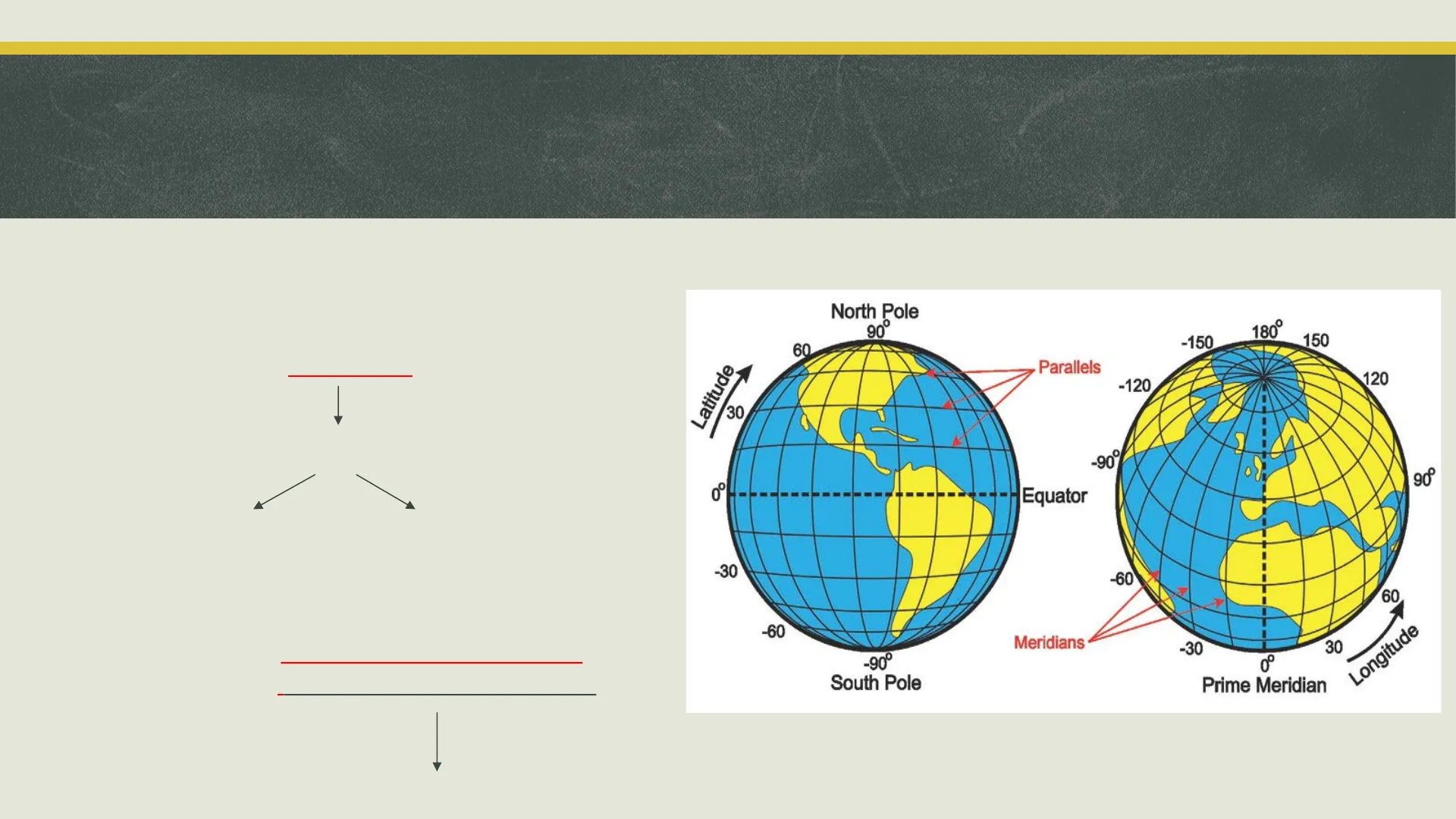
V 2. PLANET EARTH MOVEMENT OF THE EARTHGEOGRAPHIC NETWORK • The Earth is sectioned into 360 MERIDIANS and 180 PARALLELS. • PARALLEL O is the EQUATOR divides the Earth into: Northern Hemisphere Southern Hemisphere • Meridian 0 is the GREENWICH MERIDIAN or Greenwich mean time North Pole 90° 180° 150 60 Parallels 120 -120 A -90° 90 0 - Equator -30 -60 60 -60 Meridians -30 30 Longitude -90° South Pole Prime Meridian • From this point Time Zones are calculated. -150 Latitude 30MOTIONS of the PLANET EARTH
Motion of Rotation
MOTION OF ROTATION The Earth rotates on its Axis Duration : 24 hours Alternating of Day and Night Earth tilt Polar day DAY EQUATOR SUN RAYS NIGHT Polar nightThe MOTIONS of the EARTH
Motion of Revolution
MOTION OF REVOLUTION - The Earth revolves around the sun following an elliptical orbit. Duration: 365 days (a year) 21 marzo equinozio di primavera PRIMAVERA excinozi INVERNO linea dei solstizi Alinea degli 21 giugno solstizio d'estate ESTATE AUTUNNO 22 dicembre solstizio d'inverno 23 settembre equinozio d'autunno Alternating of seasonsMOTIONS OF THE EARTH
Equinox and Solstice
During the MOTION OF REVOLUTION there are: • EQUINOX The duration of day and night is the same all over the Earth. SOLSTICE: the Sun is at its highest point ( in the Northern Hemisphere in June and then the Southern Hemisphere in December) PRIMAVERA MARZO 20 EQUINOZIO DI PRIMAVERA AUTUNNO GIUGNO 20/21 SOLSTIZIO D'ESTATE ESTATE ore.it INVERNO INVERNO DICEMBRE 21/22 SOLSTIZIO D'INVERNO ESTATE Dal mio Cuore.it AUTUNNO SETTEMBRE 22/23 EQUINOZIO D'AUTUNNO PRIMAVERAVideo di ripasso
- https://www.youtube.com/watch ?v=bWikSnydub4
- https://www.youtube.com/watc h?v=TpOywo-lNlQATMOSPHERE CONTINENTAL CRUST OCEANIC CRUST HYDROSPHERE Lithosphere (Crust and upper most solid mantle) Asthenosphere Crust 0-100 km Mantle Mantle 2900 km Outer Core .5100 km Inner Core Core 6378 km EARTHTHE STRUCTURE OF THE EARTH
Earth's Layers
• The Earth is made up of different layers: CONTINENTAL CRUST . The CRUST is the outer layer that is divided into OCEANIC CRUST • The MANTLE, made of semi-liquid material like Iron and magnesium. In the upper part of the Mantle there is a solid area The CRUST + the solid area in the mantle = LITHOSPHERE. INNER CORE • The innermost layer is the CORE made of Iron and Nickel. OUTER CORE Below the Lithosphere, inside the MANTLE there is the ASTHENOSPHERE made up of red hot liquid rock: MAGMATHE MOVEMENT OF THE LITHOSPHERE
Lithosphere Movement
This structure allows the Lithosphere to float on the Asthenosphere and be in continuous movement The movements of the Lithosphere can be: slow and imperceptible or strong and violent. These movements can: Cause the slow moving of continents. Be the cause of Earthquakes and Volcanic eruptions.MOVEMENT OF THE EARTH:
Plate Tectonic Theory
THE PLATE TECTONIC THEORY This theory suggests that the Earth is made up of many pieces ( SLABS) which float on move the Asthenosphere. This movement allows the boundaries of these slabs to move away or collide.THE MOVEMENT OF THE EARTH
Origin of Geological Movement
-The Origin of Geological Movement • The Convective Motions which occur inside the Earth are the cause of these powerful movements. • Hot material found in the Mantle moves to the surface and the cooler material at the surface moves downwards. BS - 1 + 1 MODERN MANTLE CONVECTIONTHE MOVEMENT OF THE EARTH
Continental Drift Theory
THE THEORY OF THE CONTINENTAL DRIFT • German geologist Alfred Wegener, presented the theory that 200.000.000 years ago there was one single continent known as Pangea. • This continent was surrounded by a single ocean called Panthalassa. . This single continent Pangea started to break up and move apart because of the floating Tectonic Plates and the Convective motions and creating the continents in the World today.THE PLATE TECTONIC THEORY
Plate Tectonic Boundaries
We can have 1. DIVERGENT BOUNDARIES 2. CONVERGENT BOUNDARIES 3. TRANSFORM BOUNDARIES MARGINI DIVERGENTI MARGINI CONVERGENTI MARGINI TRASCORRENTI
Divergent Boundaries
1. DIVERGENT BOUNDARIES The boundaries of two plates move away from each other and form a fracture where Magma flows out. (Not Crust ocean ridge processes: Lithosphere t mantle rock rises. elt forms under the lithosphere. agma rises into magma chamber in crust and is injected as dikes forming new crust va erupts onto ocean floor adding to crust. ites move apart, cool, and thicken. Asthenosph IR This Magma then solidifies and forms a new crust. 1a-If the crust is formed on the Ocean bed it's known as Oceanic Ridge 1b-If the boundaries are on the earth there is a Rift Valley
Oceanic Ridge Example
1a-DIVERGENT BOUNDARIES: Oceanic Ridge We can see an example of divergent boundaries with the Atlantic Ridge under the land of Iceland North American Plate GREENLAND SEA Kolbeinsey Ridge Tjörnes Fracture Zone North Volcanic Zone Kraft ICELAND Snæfellsnes Volcanic Belt West Volcanic Zone Mid-Iceland Belt Öræfajökul Volcanic Belt Laki-Fogrufjoll Grimsviên REYKJAVÍK South Iceland Seismic Zone Reykjanes Ridge East Volcanic Zone Reykjanes Volcanic Belt Vatnarod Heimacy Surtsey Mid-Atlantic Ridge NORTH ATLANTIC OCEAN Eurasian Plate Mid-Atlantic Ridge
Rift Valley Example
1b-DIVERGENT BOUNDARIES Rift Valley We can see an example of divergent boundaries with the Rift Valley in Africa - Fault lines AFRICAN PLATE ARABIAN PLATE Erta' ale _. Ardoukoba AFAR DEPRESSION Lake Albert Lake Edward EASTERN - RIFT VALLEY Nyamulagira Lake Mt. Kenya Victoria OI Doinyo Lengai WESTERN RIFT Kilimanjaro VALLEY Mt. Meru Indian Ocean Lake Tanganyika Lake Rukwa Lake Mwerd •Lake Malawi https://www.youtube.com/watch?v=fnZgCGsIg3Y - Tectonic plate boundary Major active volcanoes Major dormant or extinct volcanoes Loka Turkana MI. Elgon Nyiragongo- Lac Kivu Volcan KarisimbiOceanic Ridge 1b-DIVERGENT BOUNDARIES ESPANSIONE DEI FONDALI OCEANICI
Convergent Boundaries
2-CONVERGENT BOUNDARIES The boundaries of two plates move towards each other These plate margins result in different phenomena depending on how they collide: I a. CONTINENTAL PLATE + CONTINENTAL PLATE b. OCEANIC PLATE + OCEANIC PLATE C. CONTINENTAL PLATE + OCEANIC PLATE
Continental-Continental Collision
2a-CONVERGENT BOUNDARIES: continental plate + continental plate When two Continental plates collide, we have the formation of mountain ranges: OROGENESIS. The most recent orogenesis is the formation of the Hymalayan mountain range.
Oceanic-Oceanic Collision
2b-CONVERGENT BOUNDARIES: oceanic plate + oceanic plate When two Oceanic plates collide one plate sinks under the other and along the margins VOLCANIC ISLANDS form. There are a lot of examples of this phenomena: • Eolie islands • Canarie • Japan • Philippine Islands • Marian Islands • Hawaii Earthquake Volcanoes Lithosphere Asthenosphere make a gif.com https://www.youtube.com/watch?v=fFUk0vjJcQY
Oceanic-Continental Collision
2c-CONVERGENT BOUNDARIES: oceanic plate + continental plate When an Oceanic plate collides with a continental plate the Oceanic plate sinks under the continental plate and forms an OCEANIC TRENCH. ( Mariana Trench) While the Continental plate rises upwards and forms a VOLCANIC COASTAL MOUNTAIN RANGE. tidge push Slab pull Mantle convection
Andes Mountain Range Example
2c-CONVERGENT BOUNDARIES: oceanic plate + continental plate An example is the Andes mountain range
Transform Boundaries
3-TRANSORM BOUNDARIES When the plate margins slide past each other, this causes a fracture called FAULT This is the area where very strong Earthquakes can occur. plate plate -"%ROUND RUMBLING - . ALL GASPING, WHIMPERING "
San Andreas Fault Example
3-TRANSORM BOUNDARIES A visible consequence of transform boundaries is San Andreas Fault San Andreas Fault NEVADA Sacramento O San Francisco San Jose Las Vegas O Los Angeles San DiegoTHE END! Have you got any questione? V
Can’t find what you’re looking for?
Explore more topics in the Algor library or create your own materials with AI.
