Aviation Terms, Airport Layouts, and Meteorological Phenomena
Document about aviation terms, airport layouts, and critical meteorological phenomena. The Pdf provides detailed definitions and explanations of various aviation aspects, including aerodromes, movement areas, airport markings, and critical weather events like turbulence and icing. This material is structured for university students.
See more16 Pages

Unlock the full PDF for free
Sign up to get full access to the document and start transforming it with AI.
Preview
Aerodrome Overview
An aerodrome is a defined area on land or water (including any buildings, installations, and equipment) intended to be used either wholly or in part for the arrival, departure, and surface movement of aircraft. Every airport is an aerodrome, but not every aerodrome is an airport, aerodrome is not certificate. Some examples of aerodrome are airstrip (like field with only a wind sack), seaplane bases, heliports, balloon ports. Airport is certificate.
Airport Layouts and Movement Areas
Airport layouts: airport can have very different types of shape and sizes, and they can be very complex or simple. Movement area: that part of an aerodrome to be used for the take-off, landing, and taxiing of aircraft, consisting of the maneuvering area and the apron(s).
- Apron: a defined area, on a land aerodrome, intended to accommodate aircraft for purposes of loading or unloading passengers, mail or cargo, fueling, parking or maintenance.
. Maneuvering area: that part of an aerodrome to be used for the take-off, landing, and taxiing of aircraft, excluding aprons.
-
Landing area: that part of a movement area intended for the landing or take-off of aircraft.
-
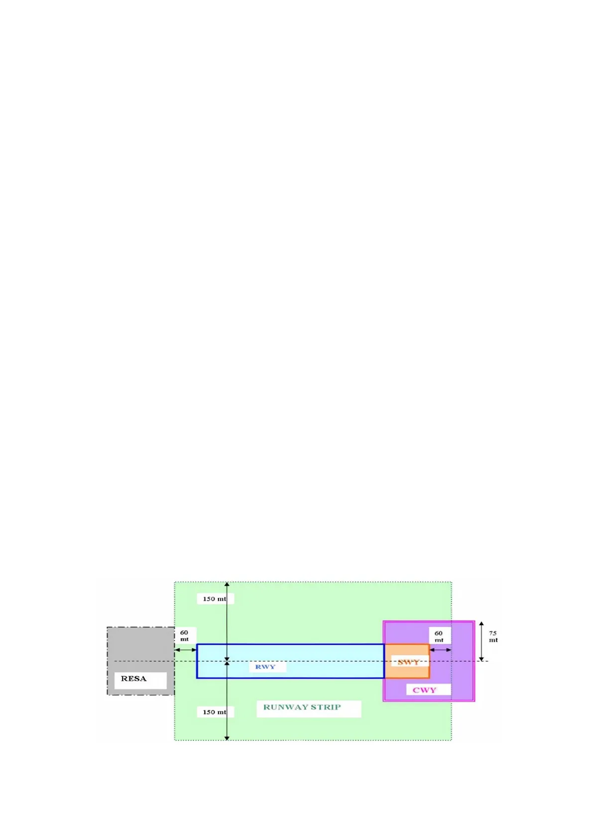
Runway strip: a defined area including the runway and stop-way, if provided, intended:
- to reduce the risk of damage to aircraft running off a runway.
-
to protect aircraft flying over it during take-off or landing operations.
-
. Stop-way: a defined rectangular area on the ground at the end of take-off run available prepared as a suitable area in which an aircraft can be stopped in the case of an abandoned take off. . Clearway: a defined rectangular area on the ground or water under the control of the appropriate authority, selected or prepared as a suitable area over which an airplane may make a portion of its initial climb to a specified height. (area to start climbing without obstacles). . Runway: a defined rectangular area on a land aerodrome prepared for the landing and take-off of aircraft.
- Runway end safety area (RESA): an area symmetrical about the extended runway center line and adjacent to the end of the strip primarily intended to reduce the risk of damage to an airplane undershooting or overrunning the runway.
150 ml 60 m 60 mt 75 mt -SW-Y -- RWY RESA CWY RUNWAY STRIP 150 ml LDA: landing distance available. TORA: take-off run available.Airborne: the altitude that indicate the successful of taking off (10,7m)
Airport Facilities and Markings
Taxiway System
Taxiway: a defined path on a land aerodrome established for the taxiing of aircraft and intended to provide a link between one part of the aerodrome and another, including:
- Aircraft stand taxi-lane: a portion of an apron designated as a taxiway and intended to provide access to aircraft stands only.
- Apron taxiway: a portion of a taxiway system located on an apron and intended to provide a through taxi route across the apron.
- Rapid exit taxiway: a taxiway connected to a runway at an acute angle and designed to allow landing airplanes to turn off at higher speeds than are achieved on other exit taxiways thereby minimizing runway occupancy times.
Airport Markings for Pilots
Airport markings Pavement markings, runway markings, etc. Witch provides indications for pilots.
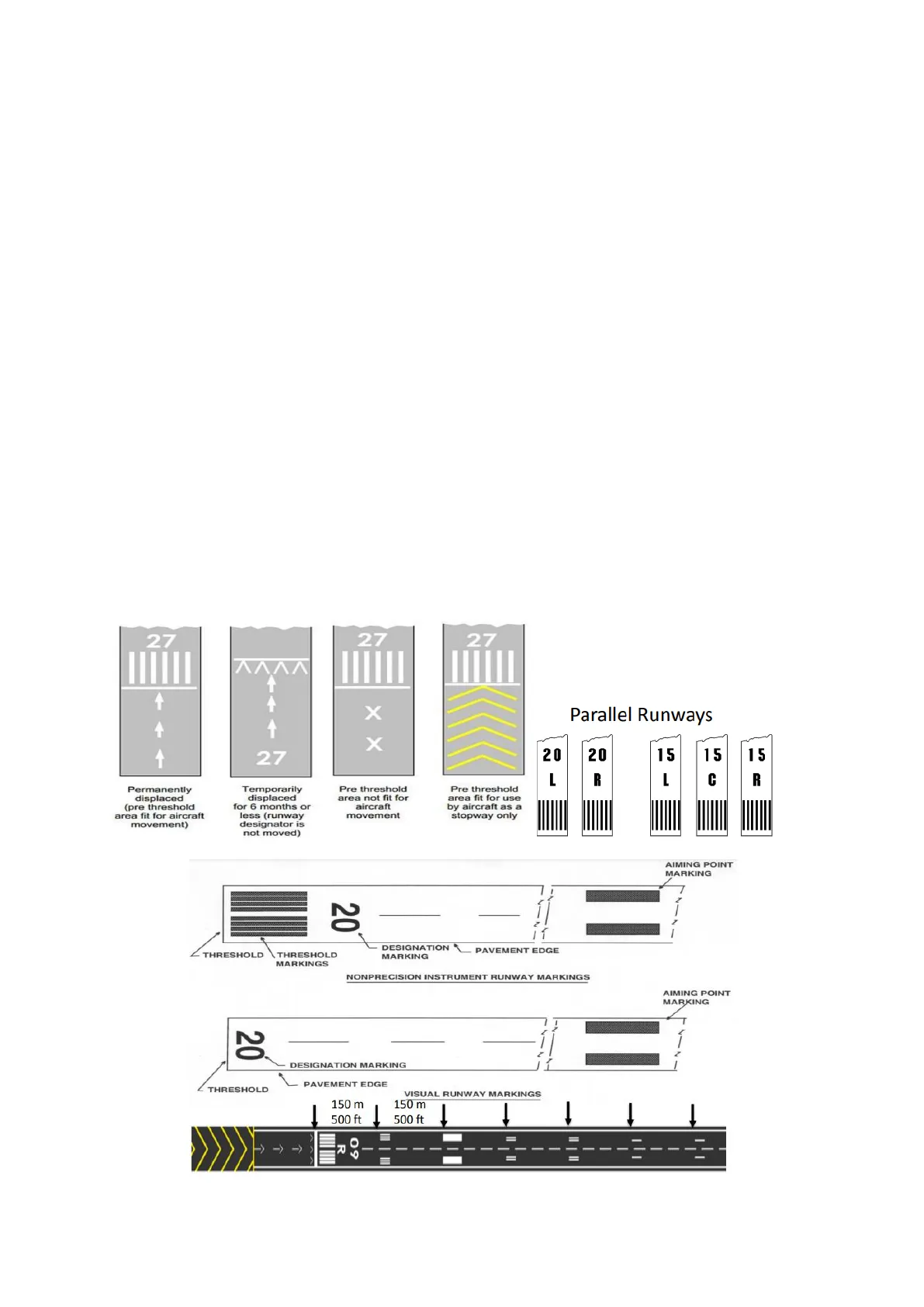
- Runway Markings: the number indicates the inclination of the runway compared with magnetic north pole. If there are parallel runways, they have also the markings which indicate the position.
- Threshold: situated at the beginning of a landing runway.
- Aiming point: they are used for measuring the length of a runways, they are also used for marking the aiming point for aircraft.
- Windsock: A windsock is a conical textile tube that resembles a giant sock. Windsocks can be used as a basic guide to wind direction and speed. Windsock can be a uniform color or alternating colors. There are mandatory sign and information sign.
- Signs: red for entrance of a runways, yellow for taxiways (also yellow markings).
27 AAAA +++ > Pre threshold area not fit for aircraft movement Pre threshold area fit for use by aircraft as a stopway only Parallel Runways 20 20 15 15 15 1 R L C R AIMING POINT MARKING 20 THRESHOLD THRESHOLD MARKINGS DESIGNATION PAVEMENT EDGE MARKING NONPRECISION INSTRUMENT RUNWAY MARKINGS AIMING POINT MARKING 20 DESIGNATION MARKING PAVEMENT EDGE THRESHOLD VISUAL RUNWAY MARKINGS 150 m 150 m 500 ft I 1 1 1 = -> > >> R 09 27 X + 1 27 Permanently displaced (pre threshold area fit for aircraft movement) Temporarily displaced for 6 months or less (runway designator is not moved) 27 I í] 500 ftPavement bearing strength. Expressed by a Pavement Classification Number (PCN). What is taken into consideration: pavement type, sub-grade strength, maximum tire pressure, evaluation method; depends on season. Aircraft Classification Number (ACN): a number expressing the relative effect of an aircraft on a pavement for a specified standard sub- grade category. General Rule: ACN ≤ PCN No operating limits
Aeronautical Phraseology
Phraseology Aeronautical phraseology is a set of communication rules for simplified English language communication between an air traffic controller and the pilot in command of an aircraft. In most countries, the aeronautical phraseology in use is based on standards developed by the International Civil Aviation Organization (ICAO). What happens when phraseology is not enough? Misunderstandings. Phraseology uses standard pronunciation for letters and numbers. Some standard word and phrases are:
- Affirm: yes
- Contact: establish communication with ...
- Correct: True or Accurate
- Roger: I have received all my last transmission.
- I say again: I repeat for clarity or emphasis.
Phonetic alphabet is used to spell somethings. Aircraft Call signs CCA 238 Flight level FL 200 Heading 100 degrees Wind 160 deg gusting 30 ktn Transponder codes Squawk 2 4 00 Runway 27 Altimeter settings QNH 1010 Altitude 3 400 Visibility 1000 Cloud height 2 200 Runway visual range RVR 600 Frequencies 1 1 8 decimal 0 (118000) Downwind RWY 05 R Base RWY 05 Crosswind RWY 05 05 Final RWY 05 23 Upwind RWY 05 Clearance, delivery, start up, push back, taxi, take-off, climb, cruise, descent, approach, landing, taxi, shutdown.
Aircraft Equipment and Instruments
Flight Instruments
Equipment Instrument: provide the pilot with data about the flight situation of that aircraft, such as altitude, airspeed etc. Gauge: device used to make measurements or to display certain dimensional information. Flight instrumentsB - C H The six pack:
- Airspeed indicator: indicate the airspeed of an aircraft.
- Vertical speed indicator (variometer) is used to inform the pilot of the rate of descent or climb. It is connected to the aircraft's external static pressure source.
- Altimeter: is used to measure the altitude of an object above a fixed level. The measurement of altitude is called altimetry. To obtain an accurate altitude reading in either feet or meters, the local barometric pressure must be calibrated correctly.
- Turn coordinator: the turn coordinator is a further development of the turn and slip indicator with the major difference being the display and the axis upon which the gimbal is mounted. The display is that of a miniature airplane as seen from behind. "no pitch information" is usually written on the instrument to avoid confusion regarding the aircraft's pitch.
- Artificial horizon: the attitude indicator informs the pilot of the aircraft orientation relative to Earth's horizon and gives an immediate indication of the smallest orientation change. The miniature aircraft and horizon bar mimic the relationship of the aircraft relative to the actual horizon. It is a primary instrument for flight in instrument meteorological conditions.
- Directional gyroscope (heading indicator): is used in an aircraft to inform the pilot of the aircraft's heading.
Heading Indicator Vacuum relief valve Overboard vont line Vacuum pump Suction Gauge Altitude Indicator Vacuum air filter Pitot tube: is a flow measurement device used to measure fluid flow velocity. Static ports: measure the real pressure. Pitot-static system is most often used in aviation to determine an aircraft's airspeed, Mach number, altitude, and altitude trend. A pitot-static system generally consists of a pitot tube, a static port, and the pitot-static instruments. Errors in pitot-static system readings can be extremely dangerous as the information obtained from the pitot static system, such as altitude, is potentially safety-critical.Airspeed indicator (ASI) Vertical speed indicator (VSI) Altimeter Pressure chamber Static chamber Static port O Baffle plate Pitot tube Drain hole Ram air Static hole ON OFF Heater (35 watts) Heater (100 watts) Pitot heater switch Alternate static source Vacuum system: is used for gyroscope instruments, there is a vacuum pump to keep they in function.
Navigation Instruments
- Magnetic compass: functions as a pointer to magnetic north.
- Radio Magnetic indicator (RMI): this is an advanced instrument as it automatically rotates the compass rose to represent the current aircraft heading at the top. The Magnetic Bearing can be obtained easily. The yellow needle point to the radio station.
- Course deviation indicator (CDI): is an avionics instrument used in aircraft navigation to determine an aircraft's lateral position in relation to a course.
- Marker beacon receiver is a particular type of VHF radio beacon used in aviation, usually in conjunction with an instrument landing system (ILS), to give pilots a means to determine position along an established route to a destination such as a runway. It plays sound if you fly over it.
- ILS: is a radio navigation system that provides short-range guidance to aircraft to allow them to approach a runway at night or in bad weather. Is composed by a glide scope (vertical antenna at the half length of the runway) that give information about the altitude relative to runway, And localizer (horizontal antenna at the end of the runway) that gives information about the correct course for approaches.
- Automatic direction finder (ADF) is or aircraft radio-navigation instrument that automatically and continuously displays the relative bearing from the ship or aircraft to a suitable radio station. ADF receivers are normally tuned to aviation NDB.
- Distance measuring equipment (DME): is a radio navigation technology that measures the distance between an aircraft and a ground station.
- Inertial reference system (INS): is a navigation device that uses a computer, accelerometers, and gyroscopes to continuously calculate by dead reckoning the position, the orientation, and the velocity of a moving object without the need for external references.
Communication Equipment
- NAV/COOM radio allows communications between the aircraft and the tower
- Transponder: is an electronic device that send info about route and aircraft to the tower. Aircraft have transponder to assist in identifying them on air traffic control radar.
- SELCAL (UHF): is a selective-calling radio system that can alert an aircraft's crew that a ground radio station wishes to communicate with the aircraft.
Multi-function Instruments
- Horizontal situation indicator (HSI): is an aircraft flight instrument normally mounted below the artificial horizon in place of a conventional heading indicator. It combines a heading indicator with a VHF omnidirectional range-instrument landing system (VOR ILS) display. This reduces pilot workload by lessening the number of elements in the pilot's instrument scan to the six basic flight instruments. The HSI offers freedom from the confusion of reverse sensing on an instrument landing system localizer back course approach.
Can’t find what you’re looking for?
Explore more topics in the Algor library or create your own materials with AI.
